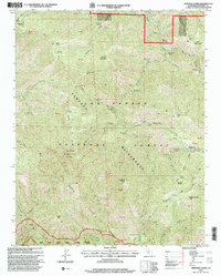
1995 Map of Ventana Cones
USGS Topo · Published 2000About this map
Ventana Wilderness dominates this mid-1990s revision of the Santa Lucia Range, revealing a landscape defined by deep canyons and high peaks within the Los Padres National Forest. The map traces a complex network of backcountry infrastructure, from the high elevation Ventana Double Cone Lookout to numerous interior campsites like Pine Valley Campsite and Bear Basin Campsite. The survey captures the intricate drainage systems of the Carmel River and the Big Sur Wild and Scenic River, illustrating the rugged topography that necessitated the designation of these protected areas. The presence of numerous named camps such as Hiding Canyon Campsite and Buckskin Flat Campsite reflects the area's established role for wilderness recreation. Surveyors also documented various trails including the Miller Canyon Trail and Puerto Suello Trail, providing a clear view of the primary transit corridors through this roadless terrain.
Find a feature on this map
81 named features on this map. Tap any name to fly to it.
Don’t see what you’re looking for? This feature index may not catch every label — zoom into the map to look around manually.
Map Details
Editions of this 1995 Ventana Cones Map
This is the sole edition of this map. No revisions or reprints were ever made.
Other maps of this area

1918 · Point Sur
USGS Topo · 1:62,500

1920 · Jamesburg
USGS Topo · 1:48,000

1921 · Jamesburg
USGS Topo · 1:62,500

1921 · Lucia
USGS Topo · 1:62,500

1925 · Point Sur
USGS Topo · 1:62,500

1939 · Jamesburg
USGS Topo · 1:62,500

1940 · Jamesburg
USGS Topo · 1:62,500

1941 · Lucia
USGS Topo · 1:62,500

1947 · Lucia
USGS Topo · 1:62,500

1947 · Jamesburg
USGS Topo · 1:62,500