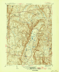
1946 Map of Verbank
USGS Topo · Published 1946About this map
Verbank Village and the surrounding townships of Union Vale and Washington define this mid-century landscape of Central Dutchess County. The terrain is shaped by the parallel ridges of Chestnut Ridge and Clove Mountain, creating the distinct agricultural basin of Clove Valley. This era shows a community structured around small school districts and local landmarks, including the Hope Farm Greer School and several rural schoolhouses like Sunnyside Sch and Clove Sch.
Find a feature on this map
43 named features on this map. Tap any name to fly to it.
Don’t see what you’re looking for? This feature index may not catch every label — zoom into the map to look around manually.
Map Details
Editions of this 1946 Verbank Map
3 editions found
Other maps of this area

1893 · Clove
USGS Topo · 1:62,500

1893 · Poughkeepsie
USGS Topo · 1:62,500

1894 · Clove
USGS Topo · 1:62,500

1894 · Poughkeepsie
USGS Topo · 1:62,500

1898 · Clove
USGS Topo · 1:62,500

1898 · Rhinebeck
USGS Topo · 1:62,500

1899 · Millbrook
USGS Topo · 1:62,500

1901 · Clove
USGS Topo · 1:62,500

1902 · Millbrook
USGS Topo · 1:62,500

1903 · Poughkeepsie
USGS Topo · 1:62,500