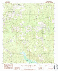
1983 Map of Verda
USGS Topo · Published 1984About this map
Kisatchie National Forest dominates the timbered uplands of this 1980s landscape, straddling the Winn Parish Grant Parish line. The terrain is defined by a dense network of watercourses, including Nantachie Creek and L'Eau Frete Creek, which feed into the sprawling waters of Nantachie Lake in the south. This area illustrates the late 20th-century rural settlement patterns of Central Louisiana, where small communities like Verda and New Verda are situated along regional roads, and the Kansas City Southern and Louisiana and Arkansas Railway provide critical transportation infrastructure for the region. Genealogists will find several rural landmarks of interest, including the Dortigo Cem and numerous parish churches such as Union Grove Ch, New Hope Ch, and Mt Zion Ch that served these dispersed communities.
Find a feature on this map
31 named features on this map. Tap any name to fly to it.
Don’t see what you’re looking for? This feature index may not catch every label — zoom into the map to look around manually.
Map Details
Editions of this 1983 Verda Map
This is the sole edition of this map. No revisions or reprints were ever made.
Other maps of this area

1932 · Colfax SW
USGS Topo · 1:31,680

1932 · Colfax NW
USGS Topo · 1:31,680

1935 · Verda
USGS Topo · 1:31,680

1936 · Colfax
USGS Topo · 1:62,500

1937 · Aloha
USGS Topo · 1:31,680

1937 · Montgomery
USGS Topo · 1:62,500

1937 · Cloutierville
USGS Topo · 1:31,680

1942 · Montgomery
USGS Topo · 1:62,500

1945 · Montgomery
USGS Topo · 1:62,500

1949 · Calvin SE
USGS Topo · 1:31,680