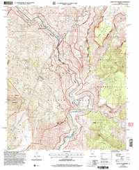
2004 Map of Verde Hot Springs
USGS Topo · Published 2006About this map
Verde Hot Springs sits at the heart of this rugged landscape where the Verde River carves through central Arizona. This 2004 revision by the Forest Service highlights a convergence of major public lands, including the Coconino National Forest, Tonto National Forest, and the northern reaches of the Mazatzal Wilderness. The map captures the industrial legacy of the area at the Childs Powerplant (Site) along the river, while tracing the paths of Fossil Creek and the East Verde River. The terrain is defined by dramatic elevation changes at Deadman Mesa and Limestone Hills, punctuated by springs and tanks such as Quail Spring and Deadman Tank that were vital for survival and ranching. Remote outposts like Lancaster and the winding Deadman Trail suggest a long history of cattle movement and exploration through the Fossil Springs and Pine Mountain Wilderness areas.
Find a feature on this map
49 named features on this map. Tap any name to fly to it.
Don’t see what you’re looking for? This feature index may not catch every label — zoom into the map to look around manually.
Map Details
Editions of this 2004 Verde Hot Springs Map
This is the sole edition of this map. No revisions or reprints were ever made.
Other maps of this area

1887 · Verde
USGS Topo · 1:250,000

1892 · Verde
USGS Topo · 1:250,000

1929 · Turret Peak
USGS Topo · 1:125,000

1933 · Turret Peak
USGS Topo · 1:125,000

1954 · Holbrook
USGS Topo · 1:250,000

1957 · Holbrook
USGS Topo · 1:250,000

1958 · Holbrook
USGS Topo · 1:250,000

1960 · Holbrook
USGS Topo · 1:250,000
1967 · Tule Mesa
USGS Topo · 1:24,000
1967 · Hackberry Mtn.
USGS Topo · 1:24,000