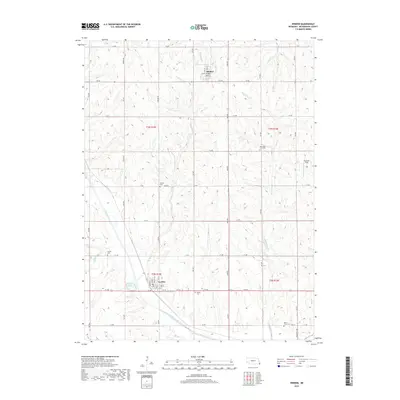
2017 Map of Verdon
USGS Topo · Published 2017About this map
Verdon and Shubert anchor this rural section of Richardson County, showing the agricultural character of southeastern Nebraska in the early 21st century. The landscape is defined by the drainage basins of Muddy Creek and Sardine Cr, where the undulating terrain is partitioned by a rigorous grid of section-line roads such as 715 Rd and 648 Ave. For genealogists, the map is particularly useful for locating community burial grounds including New Saint Anns Cem, Cupola Cem, and Maple Grove Cem. Local landmarks like the Verdon Lake recreation area and the Eickhoff Strip provide insight into the recreational and private land uses of the area. The small-town street grids of Verdon and Shubert remain concentrated, preserving the historical footprints of these prairie settlements amidst the surrounding farmsteads and creeks like Whisky Run.
Find a feature on this map
48 named features on this map. Tap any name to fly to it.
Don’t see what you’re looking for? This feature index may not catch every label — zoom into the map to look around manually.
Map Details
Editions of this 2017 Verdon Map
This is the sole edition of this map. No revisions or reprints were ever made.
Other maps of this area

1915 · Falls City
USGS Topo · 1:62,500

1915 · Nemaha
USGS Topo · 1:62,500

1915 · Howe
USGS Topo · 1:62,500

1916 · Humboldt
USGS Topo · 1:62,500

1939 · Nemaha
USGS Topo · 1:62,500

1949 · Nemaha
USGS Topo · 1:62,500

1955 · Nebraska City
USGS Topo · 1:250,000

1957 · Nebraska City
USGS Topo · 1:250,000

1958 · Nebraska City
USGS Topo · 1:250,000
1965 · Salem
USGS Topo · 1:24,000