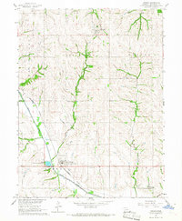
1966 Map of Verdon
USGS Topo · Published 1967About this map
The village of Verdon and its surrounding agricultural landscape in Richardson County are defined by the convergence of several waterways including West Muddy Creek, East Muddy Creek, and Sardine Creek. The Missouri Pacific Railroad cuts through the southwest, serving as a primary transportation artery for the region. This 1966 survey documents a well-established rural infrastructure of one-room schoolhouses and community landmarks, such as the Pleasant Hill Sch and Maple Grove Sch. Local history is preserved in numerous burial grounds across the township, including New St Anns Cem and Cupola Cem. The creation of the Verdon State Recreation Area south of the village highlights a shift toward water management and public leisure in the mid-20th century.
Find a feature on this map
28 named features on this map. Tap any name to fly to it.
Don’t see what you’re looking for? This feature index may not catch every label — zoom into the map to look around manually.
Map Details
Editions of this 1966 Verdon Map
This is the sole edition of this map. No revisions or reprints were ever made.
Other maps of this area

1915 · Falls City
USGS Topo · 1:62,500

1915 · Nemaha
USGS Topo · 1:62,500

1915 · Howe
USGS Topo · 1:62,500

1916 · Humboldt
USGS Topo · 1:62,500

1939 · Nemaha
USGS Topo · 1:62,500

1949 · Nemaha
USGS Topo · 1:62,500

1955 · Nebraska City
USGS Topo · 1:250,000

1957 · Nebraska City
USGS Topo · 1:250,000

1958 · Nebraska City
USGS Topo · 1:250,000
1965 · Salem
USGS Topo · 1:24,000