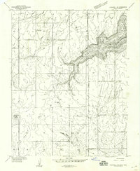
1959 Map of Verdure 1 NE
USGS Topo · Published 1959About this map
East Summit School and Burr School anchor this late 1950s map of the high plateau region where Utah meets Colorado. This survey provides a rare look at the area's rural landscape before significant modernization, revealing a network of irrigation through numerous small Reservoirs and natural water sources like Ingram Spring and Piute Spr. The terrain is defined by dramatic vertical drops into deep gorges, most notably Hamm Canyon and Wildhorse Canyon. Prominent landmarks such as Bishop Point and Piute Knoll mark the horizon, while a solitary Shaft and a long-distance Pipeline hint at the extractive industries and infrastructure shaping the San Juan County backcountry. The map also records the precise tri-county junction of San Juan, San Miguel, and Dolores counties.
Find a feature on this map
18 named features on this map. Tap any name to fly to it.
Don’t see what you’re looking for? This feature index may not catch every label — zoom into the map to look around manually.
Map Details
Editions of this 1959 Verdure 1 NE Map
This is the sole edition of this map. No revisions or reprints were ever made.
Other maps of this area

1885 · La Sal
USGS Topo · 1:250,000

1886 · Abajo
USGS Topo · 1:250,000

1892 · Abajo
USGS Topo · 1:250,000

1893 · Abajo
USGS Topo · 1:250,000

1916 · Paradox Valley
USGS Topo · 1:125,000

1922 · Paradox Valley
USGS Topo · 1:125,000

1948 · Horse Range Mesa
USGS Topo · 1:24,000

1949 · Egnar
USGS Topo · 1:24,000

1950 · Horse Range Mesa
USGS Topo · 1:24,000

1950 · Egnar
USGS Topo · 1:24,000