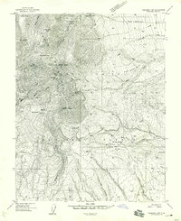
1958 Map of Verdure 2 SW
USGS Topo · Published 1958About this map
Abajo Mountains dominate this high-altitude landscape, rising to prominent points like Abajo Peak and Horsehead Peak. The 1950s terrain is marked by industrial activity and recreation within the Manti-La Sal National Forest. Mining history is evident at the Dream Mine and Gold Queen Mine, located near the steep drainage of Gold Queen Basin Creek. The map documents a specific era of mountain use, showing localized settlements such as Dalton Trailer Camp and the Blue Mtn Dude Ranch. Transport into these peaks relied on primitive routes like the North Creek Road and various jeep trails that navigate complex passes including Cooley Pass and Dickson Pass. From the headwaters of Recapture Creek to the deep incisions of Devil Canyon, the survey captures a rugged network of springs and peaks before modern development reached this part of San Juan County.
Find a feature on this map
41 named features on this map. Tap any name to fly to it.
Don’t see what you’re looking for? This feature index may not catch every label — zoom into the map to look around manually.
Map Details
Editions of this 1958 Verdure 2 SW Map
This is the sole edition of this map. No revisions or reprints were ever made.
Other maps of this area

1886 · Abajo
USGS Topo · 1:250,000

1892 · Abajo
USGS Topo · 1:250,000

1893 · Abajo
USGS Topo · 1:250,000

1935 · Elk Ridge
USGS Topo · 1:96,000

1940 · Elk Ridge
USGS Topo · 1:125,000

1954 · Elk Ridge 1 NE
USGS Topo · 1:24,000

1954 · Elk Ridge 1 SE
USGS Topo · 1:24,000
1954 · Mt Linnaeus
USGS Topo · 1:62,500

1955 · Verdure 2 SE
USGS Topo · 1:24,000

1955 · Verdure 3 NE
USGS Topo · 1:24,000