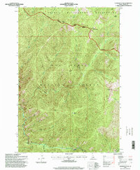
1995 Map of Vermilion Peak
USGS Topo · Published 1999About this map
Nez Perce National Forest and the Selway Bitterroot Wilderness dominate this high-elevation landscape in north-central Idaho. The terrain is defined by the sharp rise of Copper Ridge and prominent summits including Vermilion Peak and Copper Butte. A rare point of human infrastructure in this backcountry is the Meadow Creek Work Center, located near the confluence of several drainages. Transport into the area is limited to primitive routes like Tramway and the Elk City Selway Rd, which follow the deep river valleys. The map shows a clear division of land management, with the Wilderness Boundary and Ranger District Boundary cutting across peaks like Little Copper Butte and the flats of Drake Saddle. Drainage systems like Meadow Creek and Lake Creek form the primary corridors through these steep mountain ranges.
Find a feature on this map
29 named features on this map. Tap any name to fly to it.
Don’t see what you’re looking for? This feature index may not catch every label — zoom into the map to look around manually.
Map Details
Editions of this 1995 Vermilion Peak Map
This is the sole edition of this map. No revisions or reprints were ever made.
Other maps of this area

1911 · Lolo
USGS Topo · 1:250,000

1913 · Lolo
USGS Topo · 1:250,000

1956 · Elk City
USGS Topo · 1:250,000

1956 · Hamilton
USGS Topo · 1:250,000

1959 · Hamilton
USGS Topo · 1:250,000

1960 · Elk City
USGS Topo · 1:250,000

1960 · Hamilton
USGS Topo · 1:250,000

1964 · Hamilton
USGS Topo · 1:250,000

1966 · Selway Falls
USGS Topo · 1:24,000

1966 · Green Mtn.
USGS Topo · 1:24,000