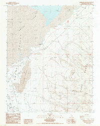
1987 Map of Vermillion Canyon
USGS Topo · Published 1987About this map
Owens Lake and the arid expanse of the Owens Valley dominate this late-twentieth-century landscape, revealing a region defined by mineral extraction and geothermal activity. The eastern portion is anchored by the Coso Range, where Vermillion Canyon and Red Ridge overlook a terrain marked by several prospects, a Claypit, and an Open Pit Mine. Along the western edge, the small settlement of Grant and a nearby Trailer Pk sit adjacent to a Landing Strip, serving as isolated hubs of human activity in the high desert.
Find a feature on this map
24 named features on this map. Tap any name to fly to it.
Don’t see what you’re looking for? This feature index may not catch every label — zoom into the map to look around manually.
Map Details
Editions of this 1987 Vermillion Canyon Map
This is the sole edition of this map. No revisions or reprints were ever made.
Other maps of this area

1905 · Olancha
USGS Topo · 1:125,000

1907 · Olancha
USGS Topo · 1:125,000

1908 · Ballarat
USGS Topo · 1:250,000

1913 · Ballarat
USGS Topo · 1:250,000

1948 · Death Valley
USGS Topo · 1:250,000

1948 · Fresno
USGS Topo · 1:250,000

1951 · Keeler
USGS Topo · 1:62,500

1951 · Haiwee Reservoir
USGS Topo · 1:62,500

1954 · Death Valley
USGS Topo · 1:250,000

1955 · Fresno
USGS Topo · 1:250,000