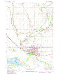
1969 Map of Vermillion
USGS Topo · Published 1980About this map
The city of Vermillion serves as the focal point of this survey, dominated by the campus of the University of South Dakota and a network of residential streets such as Main St and University St. Situated at the confluence of the Vermillion River and the broad Missouri River valley, the area shows a landscape defined by both academic growth and agricultural management. The Chicago Milwaukee St Paul and Pacific railroad tracks cut through the lowlands, linking the town to the wider Missouri River Basin.
Find a feature on this map
39 named features on this map. Tap any name to fly to it.
Don’t see what you’re looking for? This feature index may not catch every label — zoom into the map to look around manually.
Map Details
Editions of this 1969 Vermillion Map
2 editions found
Other maps of this area

1898 · Elk Point
USGS Topo · 1:125,000

1901 · Elk Point
USGS Topo · 1:125,000

1907 · Elk Point
USGS Topo · 1:125,000

1955 · Sioux City
USGS Topo · 1:250,000

1958 · Sioux City
USGS Topo · 1:250,000

1959 · Sioux City
USGS Topo · 1:250,000

1964 · Burbank
USGS Topo · 1:24,000

1964 · Maskell
USGS Topo · 1:24,000

1968 · Obert
USGS Topo · 1:24,000
1968 · Meckling
USGS Topo · 1:24,000
Featured Places
- Vermillion, SD
- Vermillion Township, SD
- Spirit Mound Township, SD
- Fairview Township, SD
- Hooker Township, NE