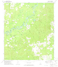
1972 Map of Vernal
USGS Topo · Published 1975About this map
The Chickasawhay River meanders through this portion of Greene County, shaping a landscape defined by its oxbow lakes and river bends. Features like Foshee Eddy, Kennard Lake, and Fence Lake mark the ancient path of the river, while the settlement of Vernal serves as a small inland hub for the surrounding rural area. The map is particularly rich for genealogical research, documenting several family-named burial grounds including McInnis Cem, McIntosh Cem, and the Maples McLeod Cem.
Find a feature on this map
51 named features on this map. Tap any name to fly to it.
Don’t see what you’re looking for? This feature index may not catch every label — zoom into the map to look around manually.
Map Details
Editions of this 1972 Vernal Map
This is the sole edition of this map. No revisions or reprints were ever made.
Other maps of this area

1941 · Lucedale
USGS Topo · 1:62,500

1942 · Deer Park
USGS Topo · 1:62,500

1942 · Wilmer
USGS Topo · 1:62,500

1943 · Lucedale
USGS Topo · 1:62,500

1943 · Deer Park
USGS Topo · 1:62,500

1944 · Wilmer
USGS Topo · 1:62,500

1953 · Hattiesburg
USGS Topo · 1:250,000

1953 · Mobile
USGS Topo · 1:250,000

1957 · Mobile
USGS Topo · 1:250,000

1958 · Hattiesburg
USGS Topo · 1:250,000