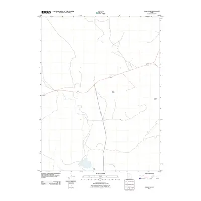
2011 Map of Vernal SW
USGS Topo · Published 2011About this map
Brough Dam anchors the southern portion of this high-desert landscape in Uintah County, illustrating the critical role of water management in the region. The map details the engineered path of the Ouray Valley Canal, which cuts through the arid terrain to support local irrigation and agriculture. Major transportation routes like the shared corridor for 40 191 and secondary roads such as Baeser Rd provide a framework for the sparse settlement and infrastructure of the early 21st century. Distinctive geographic features like Sand Wash and the broad expanse of Halfway Hollow define the natural drainage patterns, while specialized routes like 12-Mile Wash Rd offer a clear look at the area’s connectivity during this modern era of land use.
Find a feature on this map
7 named features on this map. Tap any name to fly to it.
Don’t see what you’re looking for? This feature index may not catch every label — zoom into the map to look around manually.
Map Details
Editions of this 2011 Vernal SW Map
This is the sole edition of this map. No revisions or reprints were ever made.
Other maps of this area

1885 · Ashley
USGS Topo · 1:250,000

1917 · Vernal
USGS Topo · 1:125,000

1954 · Vernal
USGS Topo · 1:250,000

1958 · Vernal
USGS Topo · 1:250,000

1960 · Vernal
USGS Topo · 1:250,000

1964 · Vernal NE
USGS Topo · 1:24,000
1964 · Fort Duchesne
USGS Topo · 1:24,000

1964 · Lapoint
USGS Topo · 1:24,000

1964 · Brennan Basin
USGS Topo · 1:24,000
1964 · Vernal SW
USGS Topo · 1:24,000