
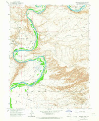
1964 Map of Brennan Basin
USGS Topo · Published 1966About this map
The Green River carves a dramatic path through this high desert landscape, creating fertile riparian zones like Brennan Bottom and Johnson Bottom. Much of this river corridor is preserved within the Ouray National Wildlife Refuge, where the wetlands of Leota Bottom and Wyasket Bottom contrast sharply with the arid tablelands of Brennan Basin.
Find a feature on this map
21 named features on this map. Tap any name to fly to it.
Don’t see what you’re looking for? This feature index may not catch every label — zoom into the map to look around manually.
Map Details
Editions of this 1964 Brennan Basin Map
2 editions found
Other maps of this area

1885 · Ashley
USGS Topo · 1:250,000

1907 · Jensen
USGS Topo · 1:125,000

1910 · Jensen
USGS Topo · 1:125,000

1917 · Vernal
USGS Topo · 1:125,000

1954 · Vernal
USGS Topo · 1:250,000

1958 · Vernal
USGS Topo · 1:250,000

1960 · Vernal
USGS Topo · 1:250,000
1964 · Vernal SW
USGS Topo · 1:24,000
1964 · Ouray
USGS Topo · 1:24,000
1964 · Pelican Lake
USGS Topo · 1:24,000