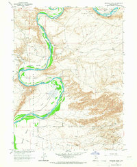
1964 Map of Brennan Basin
USGS Topo · Published 1966About this map
The Green River carves a winding path through the heart of this mid-century Uintah County landscape, defining the rich alluvial flats of Brennan Bottom and Johnson Bottom. This environment is largely protected by the Ouray National Wildlife Refuge, which spans the river's course and the low-lying Leota Bottom. To the north and south, the terrain transitions into industrial use as shown by the Horseshoe Bend Oil Field and numerous Oil Wells scattered across the Wonsits Valley.
Find a feature on this map
18 named features on this map. Tap any name to fly to it.
Don’t see what you’re looking for? This feature index may not catch every label — zoom into the map to look around manually.
Map Details
Editions of this 1964 Brennan Basin Map
2 editions found
Other maps of this area

1885 · Ashley
USGS Topo · 1:250,000

1907 · Jensen
USGS Topo · 1:125,000

1910 · Jensen
USGS Topo · 1:125,000

1917 · Vernal
USGS Topo · 1:125,000

1954 · Vernal
USGS Topo · 1:250,000

1958 · Vernal
USGS Topo · 1:250,000

1960 · Vernal
USGS Topo · 1:250,000

1964 · Brennan Basin
USGS Topo · 1:24,000
1964 · Vernal SW
USGS Topo · 1:24,000
1964 · Ouray
USGS Topo · 1:24,000