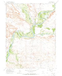
1964 Map of Ouray
USGS Topo · Published 1966About this map
The confluence of the Green River and the Duchesne River anchors this mid-century look at eastern Utah, where the White River also joins the system near the settlement of Ouray. This area is defined by the Ouray National Wildlife Refuge, which protects the river bottoms and wetlands like Old Charley Wash. The map documents the extensive footprint of the Uintah and Ouray Indian Reservation Boundary, which encloses much of the terrain.
Find a feature on this map
23 named features on this map. Tap any name to fly to it.
Don’t see what you’re looking for? This feature index may not catch every label — zoom into the map to look around manually.
Map Details
Editions of this 1964 Ouray Map
2 editions found
Other maps of this area

1885 · East Tavaputs
USGS Topo · 1:250,000

1885 · Ashley
USGS Topo · 1:250,000

1917 · Vernal
USGS Topo · 1:125,000

1953 · Nutters Hole
USGS Topo · 1:62,500

1954 · Vernal
USGS Topo · 1:250,000

1956 · Grand Junction
USGS Topo · 1:250,000

1958 · Vernal
USGS Topo · 1:250,000

1959 · Grand Junction
USGS Topo · 1:250,000

1960 · Vernal
USGS Topo · 1:250,000

1960 · Grand Junction
USGS Topo · 1:250,000