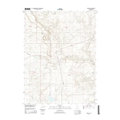
2014 Map of Vernal SW
USGS Topo · Published 2014About this map
Ouray Valley Canal and the Ouray Park Canal define the irrigation infrastructure of this Uintah County landscape. This 2014 survey shows the critical role of water management in the arid terrain, anchored by Brough Reservoir in the south. The map documents a transition from the lower elevations near Sand Wash to the dissected plateaus of Halfway Hollow. A network of thoroughfares, including Us-191 and N Highway 88, bisects the townships of T5S R19E and T6S R20E. Local ranching and land use are evident through features like S Parrish Ranch Rd and the extensive Twelvemile Wash drainage system. The layout of these canals and access roads provides a detailed picture of modern rural development and water rights in this part of eastern Utah.
Find a feature on this map
20 named features on this map. Tap any name to fly to it.
Don’t see what you’re looking for? This feature index may not catch every label — zoom into the map to look around manually.
Map Details
Editions of this 2014 Vernal SW Map
This is the sole edition of this map. No revisions or reprints were ever made.
Other maps of this area

1885 · Ashley
USGS Topo · 1:250,000

1917 · Vernal
USGS Topo · 1:125,000

1954 · Vernal
USGS Topo · 1:250,000

1958 · Vernal
USGS Topo · 1:250,000

1960 · Vernal
USGS Topo · 1:250,000

1964 · Vernal NE
USGS Topo · 1:24,000
1964 · Fort Duchesne
USGS Topo · 1:24,000

1964 · Lapoint
USGS Topo · 1:24,000

1964 · Brennan Basin
USGS Topo · 1:24,000
1964 · Vernal SW
USGS Topo · 1:24,000