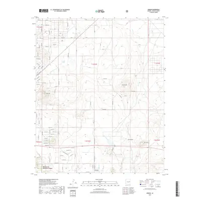
2018 Map of Vernon
USGS Topo · Published 2018About this map
Vernon occupies the southern reach of this Apache County landscape, where the high desert terrain transitions into the protected woodlands of the Sitgreaves National Forest. The map documents a complex network of county roads and named residential ways, such as Harley Davidson Rd and Cochise Trl, that weave through the subdivided sections north of the main settlement. Surface water is a defining characteristic of this arid region, marked by seasonal drainages and permanent points like Laguna Salada Spring. Prominent relief features, including Dutch Mtn and Smooth Knoll, anchor the central and western portions of the quadrangle. The presence of Anderson Lake and the smaller Lake Hole indicate significant hydrographic features that have likely influenced local land use and ranching patterns for generations. The survey provides a clear view of how rural development has expanded along the state and local road systems while maintaining proximity to the natural boundaries of the national forest.
Find a feature on this map
104 named features on this map. Tap any name to fly to it.
Don’t see what you’re looking for? This feature index may not catch every label — zoom into the map to look around manually.
Map Details
Editions of this 2018 Vernon Map
This is the sole edition of this map. No revisions or reprints were ever made.
Other maps of this area

1886 · St Johns
USGS Topo · 1:250,000

1892 · St Johns
USGS Topo · 1:250,000

1954 · Saint Johns
USGS Topo · 1:250,000

1957 · Saint Johns
USGS Topo · 1:250,000

1958 · Saint Johns
USGS Topo · 1:250,000

1961 · McNary
USGS Topo · 1:62,500

1962 · Saint Johns
USGS Topo · 1:250,000

1968 · Boundary Butte
USGS Topo · 1:24,000

1969 · Whiting Knoll
USGS Topo · 1:24,000
1971 · Cerro Hueco
USGS Topo · 1:24,000