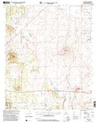
1998 Map of Vernon
USGS Topo · Published 2000About this map
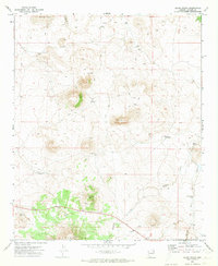
Vernon School and the high volcanic terrain of the Colorado Plateau define this landscape in the late 20th century. The area is characterized by scattered cinder cones and prominent landforms such as Smooth Knoll, Burnt Knoll, and Dutch Mountain, which rise above the surrounding juniper and pinyon woodlands of the Sitgreaves National Forest. Water management is central to the settlement pattern here, evidenced by the Mineral Ditch and a network of ephemeral basins and springs including Laguna Salada and Anderson Lake. The map identifies the historic Floy (Site), preserving its location even as modern forest roads and 4WD tracks replace older pioneer trails. The presence of a Cinder Pit underscores the local geology and the extraction of volcanic materials for infrastructure in this high-altitude Arizona environment.
Find a feature on this map
19 named features on this map. Tap any name to fly to it.
Don’t see what you’re looking for? This feature index may not catch every label — zoom into the map to look around manually.
Map Details
Editions of this 1998 Vernon Map
This is the sole edition of this map. No revisions or reprints were ever made.
Other maps of this area

1886 · St Johns
USGS Topo · 1:250,000

1892 · St Johns
USGS Topo · 1:250,000

1954 · Saint Johns
USGS Topo · 1:250,000

1957 · Saint Johns
USGS Topo · 1:250,000

1958 · Saint Johns
USGS Topo · 1:250,000
1961 · McNary
USGS Topo · 1:62,500

1962 · Saint Johns
USGS Topo · 1:250,000
1968 · Boundary Butte
USGS Topo · 1:24,000
1969 · Whiting Knoll
USGS Topo · 1:24,000
1971 · Cerro Hueco
USGS Topo · 1:24,000