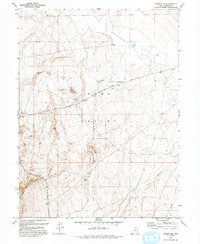
1993 Map of Vernon NE
USGS Topo · Published 1993About this map
The historical Pony Express Route and Overland Stage Route converge in this high-desert landscape, crossing the floor of Rush Valley. This 1993 edition, based on earlier surveys and field checks, identifies the Rush Valley Pony Express Station Historical Marker, a key point for those tracing the central route to California. The terrain transitions from the valley floor to the prominent Vernon Hills in the southwest, where drainage from Sabie Creek and Bowler Creek marks the seasonal hydrology of the region.
Find a feature on this map
14 named features on this map. Tap any name to fly to it.
Don’t see what you’re looking for? This feature index may not catch every label — zoom into the map to look around manually.
Map Details
Editions of this 1993 Vernon NE Map
This is the sole edition of this map. No revisions or reprints were ever made.
Other maps of this area

1885 · Tooele Valley
USGS Topo · 1:250,000

1915 · Fairfield
USGS Topo · 1:62,500

1917 · Fairfield
USGS Topo · 1:62,500

1918 · Stockton
USGS Topo · 1:62,500

1947 · Fivemile Pass
USGS Topo · 1:62,500

1947 · Boulter Peak
USGS Topo · 1:24,000

1949 · Fivemile Pass
USGS Topo · 1:24,000

1953 · Tooele
USGS Topo · 1:250,000

1955 · Stockton
USGS Topo · 1:62,500

1955 · Tooele
USGS Topo · 1:250,000