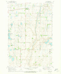
1970 Map of Verona
USGS Topo · Published 1973About this map
Verona serves as the central hub of this North Dakota prairie landscape, situated along the Northern railroad line as it cuts through the glaciated terrain of LaMoure County. The 1970 landscape is defined by its seasonal wetlands and the winding course of Bear Creek, which meanders south through Ovid and Divide townships. Significant local heritage is documented through the presence of rural cemeteries, including Pilgrims Rest Cem and St Raphael Cem, which provide valuable location data for genealogists and local historians. Large tracts of land are designated as National Wildlife Management Area, indicating a landscape focused on conservation and waterfowl habitat during this era. Scattered Gravel Pits and various fence lines, visible through aerial photography of the period, reveal the agricultural and industrial footprint of this rural community during the late 20th century.
Find a feature on this map
20 named features on this map. Tap any name to fly to it.
Don’t see what you’re looking for? This feature index may not catch every label — zoom into the map to look around manually.
Map Details
Editions of this 1970 Verona Map
This is the sole edition of this map. No revisions or reprints were ever made.
Other maps of this area

1894 · Oakes
USGS Topo · 1:62,500

1895 · Lamoure
USGS Topo · 1:125,000

1918 · La Moure
USGS Topo · 1:125,000

1952 · Glover
USGS Topo · 1:24,000

1952 · Oakes
USGS Topo · 1:24,000

1952 · Crete
USGS Topo · 1:24,000

1952 · Independence
USGS Topo · 1:24,000

1953 · Jamestown
USGS Topo · 1:250,000

1953 · Fargo
USGS Topo · 1:250,000

1956 · Fargo
USGS Topo · 1:250,000