
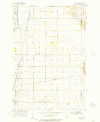
1952 Map of Glover
USGS Topo · Published 1954About this map
The James River Valley defines the landscape of this Dickey County region, where the winding James River carves deep loops across the prairie. The early 1950s infrastructure reflects a classic Midwestern rail-and-agriculture economy, anchored by the settlement of Glover in the north and Clement to the southwest. Two major rail lines intersect this territory, with the Northern Pacific serving the river valley and the Minneapolis St Paul and Sault Ste Marie cutting across the southern plains near the local Community Hall. Local history is preserved in features like the Norwegian Cem and several rural school sites such as School No 3, marking the social centers of this farming community before the consolidation of rural districts. The map also captures the confluence of Bear Creek with the main river, a key hydrological point in the drainage basin.
Find a feature on this map
13 named features on this map. Tap any name to fly to it.
Don’t see what you’re looking for? This feature index may not catch every label — zoom into the map to look around manually.
Map Details
Editions of this 1952 Glover Map
This is the sole edition of this map. No revisions or reprints were ever made.
Other maps of this area

1894 · La Moure
USGS Topo · 1:62,500

1894 · Fullerton
USGS Topo · 1:62,500

1894 · Oakes
USGS Topo · 1:62,500

1895 · Lamoure
USGS Topo · 1:125,000

1918 · La Moure
USGS Topo · 1:125,000

1952 · Oakes
USGS Topo · 1:24,000

1952 · Independence
USGS Topo · 1:24,000

1953 · Jamestown
USGS Topo · 1:250,000
1955 · Oakes SE
USGS Topo · 1:24,000

1955 · Fullerton NE
USGS Topo · 1:24,000
Featured Places
- Clement Township, ND
- Glover, ND
- Bear Creek Township, ND
- Divide Township, ND
- James River Valley Township, ND