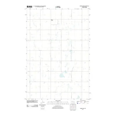
2011 Map of Verona NW
USGS Topo · Published 2011About this map
Benson Corner serves as the primary named landmark within this agricultural section of LaMoure County, situated in the northern reaches of the quadrangle. The landscape is defined by a rigorous sectional grid of gravel roads and section lines, including County Rd 34 and north-south corridors like 104th Ave SE. Numerous small prairie potholes and seasonal wetlands are scattered across the terrain, reflecting the glaciated topography of North Dakota's drift prairie. These natural depressions dictate the winding paths of field boundaries and drainage patterns amidst the steady layout of the township's rural infrastructure. This 2011 survey captures the area as a purely agrarian space, where the placement of named junctions like Benson Corner provides the few fixed points of reference for residents and researchers tracking local land ownership and the evolution of rural homesteads.
Find a feature on this map
15 named features on this map. Tap any name to fly to it.
Don’t see what you’re looking for? This feature index may not catch every label — zoom into the map to look around manually.
Map Details
Editions of this 2011 Verona NW Map
This is the sole edition of this map. No revisions or reprints were ever made.
Other maps of this area

1894 · La Moure
USGS Topo · 1:62,500

1895 · Lamoure
USGS Topo · 1:125,000

1897 · Eckelson
USGS Topo · 1:125,000

1918 · La Moure
USGS Topo · 1:125,000

1952 · Grand Rapids
USGS Topo · 1:24,000

1952 · Independence
USGS Topo · 1:24,000

1953 · Jamestown
USGS Topo · 1:250,000
1955 · La Moure
USGS Topo · 1:24,000

1956 · Jamestown
USGS Topo · 1:250,000
1970 · Verona NW
USGS Topo · 1:24,000
Featured Places
- Black Loam Township, ND
- Gladstone Township, ND
- Benson Corner, ND
- Pearl Lake Township, ND
- Greenville Township, ND