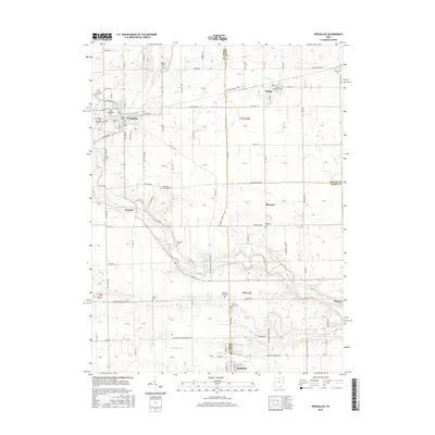
2016 Map of Versailles
USGS Topo · Published 2016About this map
The Stillwater River cuts a prominent diagonal across this West Central Ohio landscape, marking a boundary between the agricultural uplands and the river valley. The village of Versailles stands as the primary hub in the northwest, while smaller settlements like Russia, Webster, and Bloomer are interspersed among the rectangular grid of county roads. Genealogists will find a high density of burial sites reflecting the area's early settlement patterns, ranging from the Saint Valberts Cem near the northern border to the Old Harris Creek Cem further south. The drainage network is intricately detailed, featuring numerous named waterways such as Indian Cr, Swamp Cr, and Harris Cr that feed into the main river system. This terrain is characterized by a mix of natural watercourses and man-made drainage like Kluse Ditch, illustrating the intensive management of this fertile farming region.
Find a feature on this map
99 named features on this map. Tap any name to fly to it.
Don’t see what you’re looking for? This feature index may not catch every label — zoom into the map to look around manually.
Map Details
Editions of this 2016 Versailles Map
This is the sole edition of this map. No revisions or reprints were ever made.
Other maps of this area

1908 · St. Henry
USGS Topo · 1:62,500

1909 · Loramie
USGS Topo · 1:62,500

1911 · Loramie
USGS Topo · 1:62,500

1911 · Covington
USGS Topo · 1:62,500

1944 · Covington
USGS Topo · 1:62,500

1944 · Loramie
USGS Topo · 1:62,500

1953 · Muncie
USGS Topo · 1:250,000

1956 · Muncie
USGS Topo · 1:250,000

1961 · Dawn
USGS Topo · 1:24,000
1961 · Piqua West
USGS Topo · 1:24,000