1944 Map of Covington
USGS Topo · Published 1944About this map
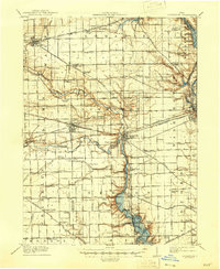
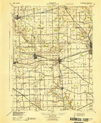
Versailles, Bradford, and Covington anchor this mid-century look at the agricultural and rail landscape of Darke, Shelby, and Miami Counties. The Pennsylvania and C C & ST L railroads drive the economy of these western Ohio towns, connecting them across the drainage of the Stillwater River and Greenville Creek. This survey, revised using aerial photography from the late 1930s, reveals a high density of one-room schoolhouses and rural churches that defined the social fabric of the era. Genealogists will find interest in the numerous named schools such as Beech Grove Sch, Mole Hill Sch, and Tadpole Sch, alongside landmarks like Greenville Falls and the Forest Hill Cem near Piqua. The map also preserves the locations of smaller rural hamlets like Bloomer, Russia, and Rowdyville, providing a detailed view of the region before significant post-war modernization.
Find a feature on this map
94 named features on this map. Tap any name to fly to it.
Don’t see what you’re looking for? This feature index may not catch every label — zoom into the map to look around manually.
Map Details
Editions of this 1944 Covington Map
This is the sole edition of this map. No revisions or reprints were ever made.