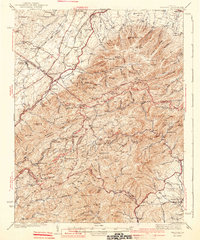
1941 Map of Vesuvius
USGS Topo · Published 1941About this map
Steeles Tavern and Vesuvius anchor the western valley floor where the Norfolk and Western and Baltimore and Ohio railroads parallel the Lee Highway. This 1930s-era survey reveals a landscape of transition, where established settlements like Greenville and Raphine give way to the rising elevations of the Blue Ridge. The ridge itself is a hub of early 20th-century development, featuring the recently established Blue Ridge Parkway and the Appalachian Trail winding through high gaps.
Find a feature on this map
142 named features on this map. Tap any name to fly to it.
Don’t see what you’re looking for? This feature index may not catch every label — zoom into the map to look around manually.
Map Details
Editions of this 1941 Vesuvius Map
2 editions found

Other maps of this area

1892 · Buckingham
USGS Topo · 1:125,000

1892 · Harrisonburg
USGS Topo · 1:125,000

1894 · Staunton
USGS Topo · 1:125,000

1894 · Lexington
USGS Topo · 1:125,000

1932 · Lexington
USGS Topo · 1:48,000

1934 · Waynesboro
USGS Topo · 1:48,000

1935 · Buena Vista
USGS Topo · 1:48,000

1935 · Amherst
USGS Topo · 1:48,000

1936 · Vesuvius
USGS Topo · 1:48,000

1937 · Lexington
USGS Topo · 1:62,500