
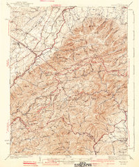
1941 Map of Vesuvius
USGS Topo · Published 1941About this map
Blue Ridge high country defines this 1930s landscape, where the intersections of early mountain industry and modern recreation are clearly visible. The survey documents the newly established Blue Ridge Parkway and the Appalachian Trail as they trace the ridges above historic settlements like Vesuvius and Steeles Tavern. A legacy of extraction is evident at the Kennedy Mine and Red Mtn Mine, while the State Trout Nursery reflects a shift toward conservation and management of the area's natural resources.
Find a feature on this map
135 named features on this map. Tap any name to fly to it.
Don’t see what you’re looking for? This feature index may not catch every label — zoom into the map to look around manually.
Map Details
Editions of this 1941 Vesuvius Map
2 editions found
Other maps of this area

1892 · Buckingham
USGS Topo · 1:125,000

1892 · Harrisonburg
USGS Topo · 1:125,000

1894 · Staunton
USGS Topo · 1:125,000

1894 · Lexington
USGS Topo · 1:125,000

1932 · Lexington
USGS Topo · 1:48,000

1934 · Waynesboro
USGS Topo · 1:48,000

1935 · Buena Vista
USGS Topo · 1:48,000

1935 · Amherst
USGS Topo · 1:48,000

1936 · Vesuvius
USGS Topo · 1:48,000

1937 · Lexington
USGS Topo · 1:62,500