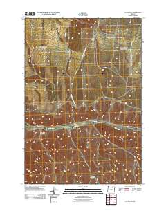
2011 Map of Vey Ranch
USGS Topo · Published 2011About this map
Butter Creek winds through the heart of this Umatilla County landscape, serving as the primary drainage for a network of deeply incised terrain. The namesake Vey Ranch sits at a critical junction where Tom Vey Rd meets the water, illustrating the continued importance of historical landholdings in this part of Oregon. The topography is defined by significant drainage systems including Morris Canyon, Matlock Canyon, and Ayers Canyon, along with their corresponding dry forks. A sparse network of forest roads and county routes, such as CO 1351 Rd and CO 1349 Rd, provide access across the high ground between these canyons. The labeling reflects a landscape of working ranches and remote access, where water sources like Butter Creek have long dictated the placement of roads and homesteads.
Find a feature on this map
14 named features on this map. Tap any name to fly to it.
Don’t see what you’re looking for? This feature index may not catch every label — zoom into the map to look around manually.
Map Details
Editions of this 2011 Vey Ranch Map
This is the sole edition of this map. No revisions or reprints were ever made.
Other maps of this area

1908 · Umatilla
USGS Topo · 1:125,000

1953 · Pendleton
USGS Topo · 1:250,000

1956 · Pendleton
USGS Topo · 1:250,000

1968 · Service Buttes NW
USGS Topo · 1:24,000

1968 · Lena
USGS Topo · 1:24,000
1968 · Echo
USGS Topo · 1:24,000

1968 · Gleason Butte
USGS Topo · 1:24,000

1968 · Vey Ranch
USGS Topo · 1:24,000

1968 · Butter Creek Junction
USGS Topo · 1:24,000
1968 · Service Buttes
USGS Topo · 1:24,000