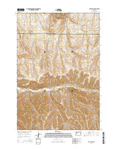
2014 Map of Vey Ranch
USGS Topo · Published 2014About this map
Vey Ranch sits at the center of this landscape in eastern Oregon, where the boundary between Umatilla and Morrow counties cuts across the high terrain. The geography is defined by a series of significant drainage systems, most notably Butter Cr, which winds through the central portion of the quadrangle. Surrounding this watercourse is a network of named canyons and hollows, including Morris Canyon, Matlock Canyon, and the appropriately named Mule Hollow.
Find a feature on this map
20 named features on this map. Tap any name to fly to it.
Don’t see what you’re looking for? This feature index may not catch every label — zoom into the map to look around manually.
Map Details
Editions of this 2014 Vey Ranch Map
This is the sole edition of this map. No revisions or reprints were ever made.
Other maps of this area

1908 · Umatilla
USGS Topo · 1:125,000

1953 · Pendleton
USGS Topo · 1:250,000

1956 · Pendleton
USGS Topo · 1:250,000

1968 · Service Buttes NW
USGS Topo · 1:24,000

1968 · Lena
USGS Topo · 1:24,000
1968 · Echo
USGS Topo · 1:24,000

1968 · Gleason Butte
USGS Topo · 1:24,000

1968 · Vey Ranch
USGS Topo · 1:24,000

1968 · Butter Creek Junction
USGS Topo · 1:24,000
1968 · Service Buttes
USGS Topo · 1:24,000