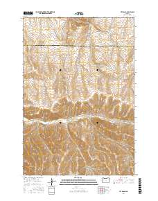
2017 Map of Vey Ranch
USGS Topo · Published 2017About this map
Butter Cr cuts through the high desert of Eastern Oregon, creating a central corridor for ranching activity in a landscape defined by sharp elevation changes and deep drainage basins. The namesake Vey Ranch sits at the nexus of several prominent landforms, including Ayers Canyon and Matlock Canyon, illustrating the importance of water access in this arid region. The boundary between Umatilla Co and Morrow Co bisects the northern section of the map, where the terrain transitions toward the service roads of the national forest. The network of canyons, such as Mule Hollow and Service Canyon, creates a complex topography that has historically dictated the routes of local thoroughfares like Big Butter Creek Ln and Service Butte Rd.
Find a feature on this map
19 named features on this map. Tap any name to fly to it.
Don’t see what you’re looking for? This feature index may not catch every label — zoom into the map to look around manually.
Map Details
Editions of this 2017 Vey Ranch Map
This is the sole edition of this map. No revisions or reprints were ever made.
Other maps of this area

1908 · Umatilla
USGS Topo · 1:125,000

1953 · Pendleton
USGS Topo · 1:250,000

1956 · Pendleton
USGS Topo · 1:250,000

1968 · Service Buttes NW
USGS Topo · 1:24,000

1968 · Lena
USGS Topo · 1:24,000
1968 · Echo
USGS Topo · 1:24,000

1968 · Gleason Butte
USGS Topo · 1:24,000

1968 · Vey Ranch
USGS Topo · 1:24,000

1968 · Butter Creek Junction
USGS Topo · 1:24,000
1968 · Service Buttes
USGS Topo · 1:24,000