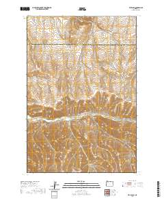
2020 Map of Vey Ranch
USGS Topo · Published 2020About this map
Vey Ranch sits at the heart of this dissected plateau region, where the high-elevation drainage network defines the movement of people and livestock. Located along the winding course of Butter Cr, the ranch remains a focal point of activity in an area otherwise characterized by deep, narrow draws. The landscape is a complex system of watercourses, including Service Canyon to the east and the branching Ayers Canyon and Dry Ayers Canyon further south.
Find a feature on this map
19 named features on this map. Tap any name to fly to it.
Don’t see what you’re looking for? This feature index may not catch every label — zoom into the map to look around manually.
Map Details
Editions of this 2020 Vey Ranch Map
This is the sole edition of this map. No revisions or reprints were ever made.
Other maps of this area

1908 · Umatilla
USGS Topo · 1:125,000

1953 · Pendleton
USGS Topo · 1:250,000

1956 · Pendleton
USGS Topo · 1:250,000

1968 · Service Buttes NW
USGS Topo · 1:24,000

1968 · Lena
USGS Topo · 1:24,000
1968 · Echo
USGS Topo · 1:24,000

1968 · Gleason Butte
USGS Topo · 1:24,000

1968 · Vey Ranch
USGS Topo · 1:24,000

1968 · Butter Creek Junction
USGS Topo · 1:24,000
1968 · Service Buttes
USGS Topo · 1:24,000