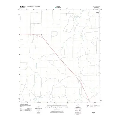
2010 Map of Vick
USGS Topo · Published 2010About this map
The settlement of Vick serves as the focal point of this Concho County survey, situated at the junction of several county roads and farm-to-market routes. The landscape is defined by the winding paths of Kickapoo Creek and Frog Pond Creek, which drain the open ranch land characteristic of this region. Near the northern boundary, Henderson Chapel stands as a notable landmark for those tracing local community history or family genealogy. The infrastructure is dominated by the diagonal transit of US Highway 87, which cuts through the territory alongside a network of rural routes including FM 381 and Co RD 1382. Further south, the confluence of smaller waterways like Welch Creek highlights the drainage patterns that have historically influenced land use and settlement in this portion of Central Texas.
Find a feature on this map
16 named features on this map. Tap any name to fly to it.
Don’t see what you’re looking for? This feature index may not catch every label — zoom into the map to look around manually.
Map Details
Editions of this 2010 Vick Map
This is the sole edition of this map. No revisions or reprints were ever made.
Other maps of this area

1892 · San Angelo
USGS Topo · 1:125,000

1892 · Eden
USGS Topo · 1:125,000

1896 · Eden
USGS Topo · 1:125,000

1954 · Brownwood
USGS Topo · 1:250,000

1954 · San Angelo
USGS Topo · 1:250,000

1957 · Eola
USGS Topo · 1:62,500

1958 · San Angelo
USGS Topo · 1:250,000

1965 · San Angelo
USGS Topo · 1:250,000
1967 · Millersview NW
USGS Topo · 1:24,000
1967 · Millersview SW
USGS Topo · 1:24,000