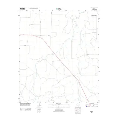
2012 Map of Vick
USGS Topo · Published 2012About this map
Vick anchors this Concho County landscape, situated at the junction of local transit routes in a region defined by its seasonal watercourses. The drainage patterns of Frog Pond Cr and Kickapoo Cr shape the terrain, illustrating the hydrological network of this West Texas prairie. To the north, Henderson Chapel stands as a focal point for the local community, while a grid of rural roads like Co Rd-1388 and Fm 381 provides access to scattered homesteads and ranching lands. The map details a transition from the early 21st-century rural infrastructure to modern highway developments such as State Loop 577, documenting the evolution of travel and settlement in a traditionally agricultural area.
Find a feature on this map
19 named features on this map. Tap any name to fly to it.
Don’t see what you’re looking for? This feature index may not catch every label — zoom into the map to look around manually.
Map Details
Editions of this 2012 Vick Map
This is the sole edition of this map. No revisions or reprints were ever made.
Other maps of this area

1892 · San Angelo
USGS Topo · 1:125,000

1892 · Eden
USGS Topo · 1:125,000

1896 · Eden
USGS Topo · 1:125,000

1954 · Brownwood
USGS Topo · 1:250,000

1954 · San Angelo
USGS Topo · 1:250,000

1957 · Eola
USGS Topo · 1:62,500

1958 · San Angelo
USGS Topo · 1:250,000

1965 · San Angelo
USGS Topo · 1:250,000
1967 · Millersview NW
USGS Topo · 1:24,000
1967 · Millersview SW
USGS Topo · 1:24,000