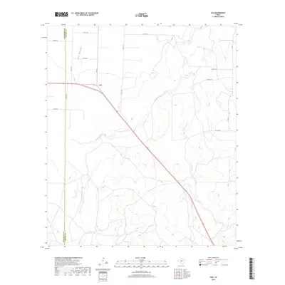
2019 Map of Vick
USGS Topo · Published 2019About this map
Vick sits at a highway junction in West Texas, marking a landscape where the flat Edwards Plateau begins to break into complex drainages. This survey captures the rural character of the Tom Green Co and Concho Co border, defined by the winding paths of Kickapoo Cr and Frog Pond Cr. The terrain is characterized by broad upland flats that drop into seasonal watercourses like Dry Hollow and Welch Cr. The map reveals a highly structured grid of county roads, such as FM 381 and Co Rd 1388, which support the region's ranching and agricultural operations. The convergence of multiple creek systems south of the settlement suggests a topography shaped by intermittent drainage, providing a clear picture of the land use patterns and property divisions at the edge of the Concho Valley in the early twenty-first century.
Find a feature on this map
18 named features on this map. Tap any name to fly to it.
Don’t see what you’re looking for? This feature index may not catch every label — zoom into the map to look around manually.
Map Details
Editions of this 2019 Vick Map
This is the sole edition of this map. No revisions or reprints were ever made.
Other maps of this area

1892 · San Angelo
USGS Topo · 1:125,000

1892 · Eden
USGS Topo · 1:125,000

1896 · Eden
USGS Topo · 1:125,000

1954 · Brownwood
USGS Topo · 1:250,000

1954 · San Angelo
USGS Topo · 1:250,000

1957 · Eola
USGS Topo · 1:62,500

1958 · San Angelo
USGS Topo · 1:250,000

1965 · San Angelo
USGS Topo · 1:250,000
1967 · Millersview NW
USGS Topo · 1:24,000
1967 · Millersview SW
USGS Topo · 1:24,000