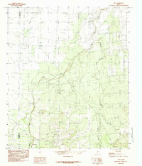
1984 Map of Vick
USGS Topo · Published 1984About this map
Vick sits at the northern edge of this landscape where the undulating plains of Central Texas meet the drainage networks of the Edwards Plateau. The terrain is defined by the southeasterly flow of Kickapoo Creek and its tributaries, including Frog Pond Creek and Welch Cr, which carve a series of breaks and draws through the ranch land. The border between Tom Green Co and Concho Co runs vertically through the western portion of the quadrangle, illustrating the political division of these rural cattle and sheep-raising counties. Outside of the small settlement at Vick, the map reflects a sparsely populated area characterized by intermittent water sources like Dry Hollow and minor industrial activity evidenced by a Gravel Pit near the creek beds.
Find a feature on this map
7 named features on this map. Tap any name to fly to it.
Don’t see what you’re looking for? This feature index may not catch every label — zoom into the map to look around manually.
Map Details
Editions of this 1984 Vick Map
This is the sole edition of this map. No revisions or reprints were ever made.
Other maps of this area

1892 · San Angelo
USGS Topo · 1:125,000

1892 · Eden
USGS Topo · 1:125,000

1896 · Eden
USGS Topo · 1:125,000

1954 · Brownwood
USGS Topo · 1:250,000

1954 · San Angelo
USGS Topo · 1:250,000

1957 · Eola
USGS Topo · 1:62,500

1958 · San Angelo
USGS Topo · 1:250,000

1965 · San Angelo
USGS Topo · 1:250,000
1967 · Millersview NW
USGS Topo · 1:24,000
1967 · Millersview SW
USGS Topo · 1:24,000