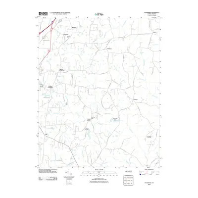
2010 Map of Vicksboro
USGS Topo · Published 2010About this map
Weldons Mill stands as a point of historic industrial interest along the banks of Sandy Creek, surrounded by a network of rural roads such as Weldons Mill Rd and Faulkner Town Rd. This 2010 survey of Vance County highlights the transition between the small community hubs and the area's natural resource extraction, most notably at the Greystone Quarry near Greystone. The landscape is defined by its numerous small-scale water management features, including the Weldons Pond Dam and Ayscues Pond Dam, which punctuate the drainage basins of Weaver Creek and Shocco Creek. From the Henderson Fire Tower in the northwest to the settlement of Vicksboro in the east, the map details a region where family-named crossroads like Adcock Crossroads and Faulkner Crossroads continue to anchor the local geography.
Find a feature on this map
88 named features on this map. Tap any name to fly to it.
Don’t see what you’re looking for? This feature index may not catch every label — zoom into the map to look around manually.
Map Details
Editions of this 2010 Vicksboro Map
This is the sole edition of this map. No revisions or reprints were ever made.
Other maps of this area

1953 · Greensboro
USGS Topo · 1:250,000

1954 · Greensboro
USGS Topo · 1:250,000

1962 · Greensboro
USGS Topo · 1:250,000

1966 · Greensboro
USGS Topo · 1:250,000

1970 · Vicksboro
USGS Topo · 1:24,000
1970 · Middleburg
USGS Topo · 1:24,000
1970 · Warrenton
USGS Topo · 1:24,000
1970 · Townsville
USGS Topo · 1:24,000

1970 · Henderson
USGS Topo · 1:24,000

1971 · Afton
USGS Topo · 1:24,000