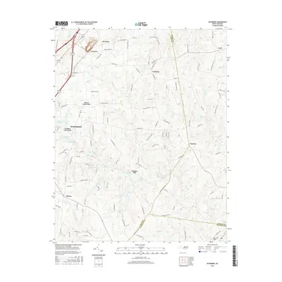
2016 Map of Vicksboro
USGS Topo · Published 2016About this map
Vicksboro and the surrounding rural communities of Vance Co sit at the intersection of long-established agricultural lands and the growing eastern suburbs of Henderson. This 2016 survey details a landscape defined by its small crossroads settlements and numerous private water bodies, such as Weldons Pond and Rowlands Pond, which suggest a history of localized milling and recreation. The terrain is marked by the drainages of Sandy Creek and Buffalo Creek, which separate the various clusters of family-named landmarks and historical junctions.
Find a feature on this map
126 named features on this map. Tap any name to fly to it.
Don’t see what you’re looking for? This feature index may not catch every label — zoom into the map to look around manually.
Map Details
Editions of this 2016 Vicksboro Map
This is the sole edition of this map. No revisions or reprints were ever made.
Other maps of this area

1953 · Greensboro
USGS Topo · 1:250,000

1954 · Greensboro
USGS Topo · 1:250,000

1962 · Greensboro
USGS Topo · 1:250,000

1966 · Greensboro
USGS Topo · 1:250,000

1970 · Vicksboro
USGS Topo · 1:24,000
1970 · Middleburg
USGS Topo · 1:24,000
1970 · Warrenton
USGS Topo · 1:24,000
1970 · Townsville
USGS Topo · 1:24,000

1970 · Henderson
USGS Topo · 1:24,000

1971 · Afton
USGS Topo · 1:24,000