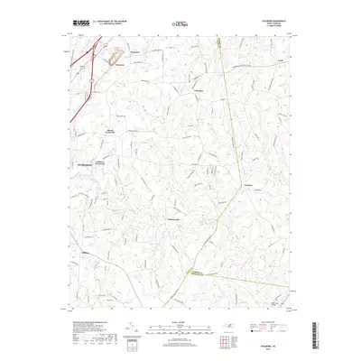
2019 Map of Vicksboro
USGS Topo · Published 2019About this map
Weldons Mill sits at a geographic crossroads south of the Vicksboro and Cokesbury communities, anchoring a landscape defined by its intricate drainage networks and rural settlements. The terrain is marked by numerous family-named landmarks and water bodies, including Ayscues Pond and Southerlands Pond, which highlight the importance of private water management in this part of North Carolina. To the northwest, the edge of Henderson meets rural junctions like Faulkner Crossroads and Adcock Crossroads, where the suburban fringe transitions into the agricultural and wooded lands that stretch toward the Warren County line. Small hamlets such as Brookston and Greystone are situated along the transit corridors in the north, while the southern reaches of the map near High Tower Bridge trace the headwaters and creeks that feed the regional river systems.
Find a feature on this map
122 named features on this map. Tap any name to fly to it.
Don’t see what you’re looking for? This feature index may not catch every label — zoom into the map to look around manually.
Map Details
Editions of this 2019 Vicksboro Map
This is the sole edition of this map. No revisions or reprints were ever made.
Other maps of this area

1953 · Greensboro
USGS Topo · 1:250,000

1954 · Greensboro
USGS Topo · 1:250,000

1962 · Greensboro
USGS Topo · 1:250,000

1966 · Greensboro
USGS Topo · 1:250,000

1970 · Vicksboro
USGS Topo · 1:24,000
1970 · Middleburg
USGS Topo · 1:24,000
1970 · Warrenton
USGS Topo · 1:24,000
1970 · Townsville
USGS Topo · 1:24,000

1970 · Henderson
USGS Topo · 1:24,000

1971 · Afton
USGS Topo · 1:24,000