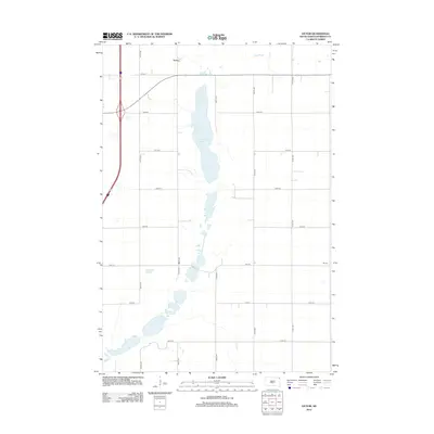
2012 Map of Victor
USGS Topo · Published 2012About this map
Victor sits at the northern edge of this Roberts County landscape, characterized by the expansive wetland systems typical of the Coteau des Prairies region. The central geography is defined by a chain of water bodies, including Cottonwood Lake and the southward-reaching Cottonwood Slough, which create a natural break in the organized grid of rural roads. In the northeast corner, Big Slough marks another significant drainage area. The small settlement of Winans occupies a modest position to the east, connected to the surrounding farmland by a network of numbered section-line roads like 110th St and 471st Ave. This survey illustrates the persistent agricultural and hydrological patterns of the Lake Traverse District in the early 21st century, showing how the local road infrastructure navigates around the prairie sloughs and lakes that dominate the terrain.
Find a feature on this map
18 named features on this map. Tap any name to fly to it.
Don’t see what you’re looking for? This feature index may not catch every label — zoom into the map to look around manually.
Map Details
Editions of this 2012 Victor Map
This is the sole edition of this map. No revisions or reprints were ever made.
Other maps of this area

1915 · White Rock
USGS Topo · 1:62,500

1916 · Peever
USGS Topo · 1:62,500

1916 · Beardsley
USGS Topo · 1:62,500

1917 · New Effington
USGS Topo · 1:62,500

1918 · Peever
USGS Topo · 1:62,500

1918 · White Rock
USGS Topo · 1:62,500

1918 · Beardsley
USGS Topo · 1:62,500

1953 · Milbank
USGS Topo · 1:250,000

1958 · Milbank
USGS Topo · 1:250,000
1971 · Peever NW
USGS Topo · 1:24,000