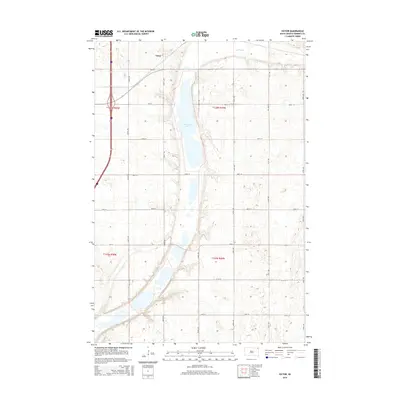
2015 Map of Victor
USGS Topo · Published 2015About this map
Victor sits near the northern boundary of this Roberts County landscape, representing a quiet agricultural crossroads in the Lake Traverse District. The topography is dominated by the linear basin of Cottonwood Lake, which stretches through the center of the quadrangle. To the northeast, the marshy expanse of Big Slough indicates the low-lying, water-rich nature of the glacial till plains. The presence of I-29 and Highway 81 on the western edge provides a stark contrast between modern transit corridors and the rigid section-line grid of local roads like 468th Ave and 107th St. This 2015 survey illustrates the enduring township and range system, with the map area divided between t128n r50w and t127n r49w, showing how contemporary land use remains bound to nineteenth-century surveying patterns.
Find a feature on this map
25 named features on this map. Tap any name to fly to it.
Don’t see what you’re looking for? This feature index may not catch every label — zoom into the map to look around manually.
Map Details
Editions of this 2015 Victor Map
This is the sole edition of this map. No revisions or reprints were ever made.
Other maps of this area

1915 · White Rock
USGS Topo · 1:62,500

1916 · Peever
USGS Topo · 1:62,500

1916 · Beardsley
USGS Topo · 1:62,500

1917 · New Effington
USGS Topo · 1:62,500

1918 · Peever
USGS Topo · 1:62,500

1918 · White Rock
USGS Topo · 1:62,500

1918 · Beardsley
USGS Topo · 1:62,500

1953 · Milbank
USGS Topo · 1:250,000

1958 · Milbank
USGS Topo · 1:250,000
1971 · Peever NW
USGS Topo · 1:24,000