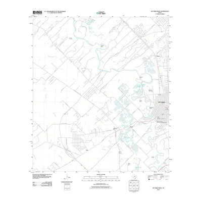
2010 Map of Victoria West
USGS Topo · Published 2010About this map
The Guadalupe River meanders through the heart of this landscape, its path defined by significant geological curves such as Powers Bend, Grovers Bend, and Foxes Bend. On the eastern bank, the urban density of Victoria is evident, featuring preserved landmarks like the Victoria Grist Windmill and the South Bridge Street Historic District. The river's historical importance to transportation is highlighted by the Southern Pacific Railroad Guadalupe Bridge and the presence of Pleasure Island near the city center.
Find a feature on this map
61 named features on this map. Tap any name to fly to it.
Don’t see what you’re looking for? This feature index may not catch every label — zoom into the map to look around manually.
Map Details
Editions of this 2010 Victoria West Map
This is the sole edition of this map. No revisions or reprints were ever made.
Other maps of this area

1951 · Bloomington
USGS Topo · 1:24,000

1951 · Inez NW
USGS Topo · 1:24,000

1952 · Victoria East
USGS Topo · 1:24,000

1953 · Beeville
USGS Topo · 1:250,000

1956 · Beeville
USGS Topo · 1:250,000

1960 · Beeville
USGS Topo · 1:250,000

1962 · Fannin
USGS Topo · 1:24,000

1962 · Raisin
USGS Topo · 1:24,000

1963 · Nursery
USGS Topo · 1:24,000
1963 · Mission Valley
USGS Topo · 1:24,000