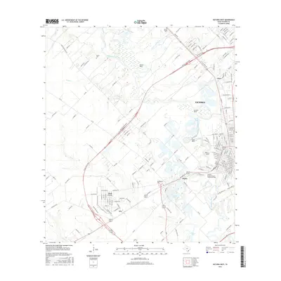
2016 Map of Victoria West
USGS Topo · Published 2016About this map
The Guadalupe River carves a winding path through this portion of south Texas, defining the landscape with a series of dramatic oxbows such as Powers Bend, Grovers Bend, and Foxes Bend. The western reaches of Victoria dominate the eastern edge of the survey, where the river's influence is seen in the creation of Pleasure Island and several water bodies like Optimist Ponds and the Saxet Lakes. This 2016 data illustrates the expansion of suburban developments into formerly rural areas, most notably the residential clusters at Quail Creek and Aloe southwest of the city center.
Find a feature on this map
175 named features on this map. Tap any name to fly to it.
Don’t see what you’re looking for? This feature index may not catch every label — zoom into the map to look around manually.
Map Details
Editions of this 2016 Victoria West Map
This is the sole edition of this map. No revisions or reprints were ever made.
Other maps of this area

1951 · Bloomington
USGS Topo · 1:24,000

1951 · Inez NW
USGS Topo · 1:24,000

1952 · Victoria East
USGS Topo · 1:24,000

1953 · Beeville
USGS Topo · 1:250,000

1956 · Beeville
USGS Topo · 1:250,000

1960 · Beeville
USGS Topo · 1:250,000

1962 · Fannin
USGS Topo · 1:24,000

1962 · Raisin
USGS Topo · 1:24,000

1963 · Nursery
USGS Topo · 1:24,000
1963 · Mission Valley
USGS Topo · 1:24,000