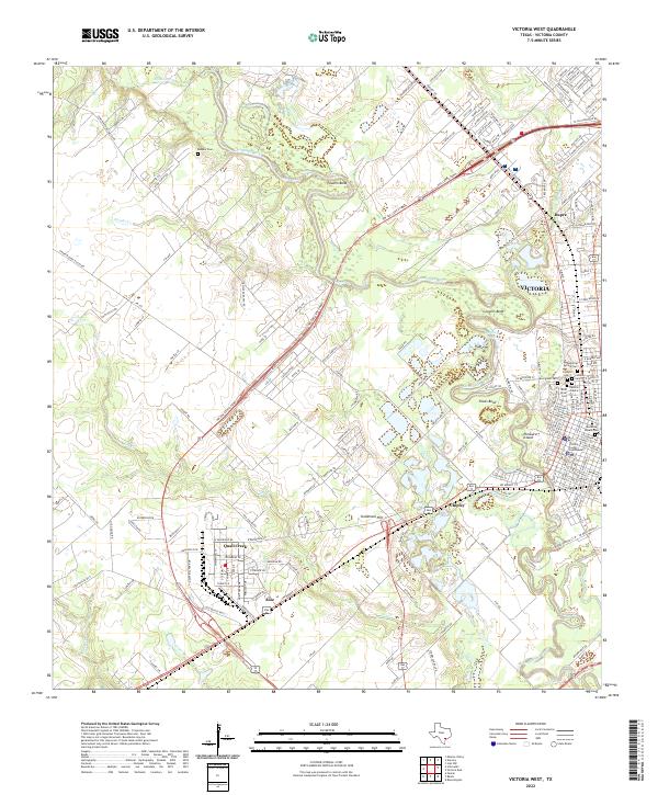
2022 Map of Victoria West
USGS Topo · Published 2022About this map
The Guadalupe River meanders through this landscape, carving deep oxbows and distinctive terrain features like Powers Bend, Grovers Bend, and Foxes Bend. On the eastern bank, the urban center of Victoria anchors the region, centered on the Victoria County Courthouse. This modern survey reveals a dense concentration of historical burial grounds that reflect the city's diverse heritage, including Memorial Square Cem, Evergreen Cem, and Bnai Israel Cem.
Find a feature on this map
188 named features on this map. Tap any name to fly to it.
Don’t see what you’re looking for? This feature index may not catch every label — zoom into the map to look around manually.
Map Details
Editions of this 2022 Victoria West Map
This is the sole edition of this map. No revisions or reprints were ever made.
Other maps of this area

1951 · Bloomington
USGS Topo · 1:24,000

1951 · Inez NW
USGS Topo · 1:24,000

1952 · Victoria East
USGS Topo · 1:24,000

1953 · Beeville
USGS Topo · 1:250,000

1956 · Beeville
USGS Topo · 1:250,000

1960 · Beeville
USGS Topo · 1:250,000

1962 · Fannin
USGS Topo · 1:24,000

1962 · Raisin
USGS Topo · 1:24,000

1963 · Nursery
USGS Topo · 1:24,000
1963 · Mission Valley
USGS Topo · 1:24,000