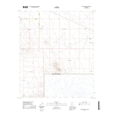
2023 Map of Victorio Ranch
USGS Topo · Published 2023About this map
Sierra Rica and the Apache Hills dominate this high-desert landscape in southwestern New Mexico, where the international boundary with Mexico meets the complex intersection of three counties. This survey documents a critical junction where Grant, Hidalgo, and Luna Counties converge, shaped by a network of water management features essential for ranching in this arid environment. The presence of the Victorio Cem in the northeastern quadrant provides a specific point of interest for genealogists and local historians tracking early settlement and family history in the region. Infrastructure is sparse, characterized primarily by Hatchet Ranch Rd and a series of livestock water sources such as Wamels Pond, International Tank, and numerous numbered tanks. The terrain is further defined by natural drainage patterns like Rock Hole Canyon and Wamels Draw, illustrating the relationship between the physical geography and the historical ranching economy.
Find a feature on this map
22 named features on this map. Tap any name to fly to it.
Don’t see what you’re looking for? This feature index may not catch every label — zoom into the map to look around manually.
Map Details
Editions of this 2023 Victorio Ranch Map
This is the sole edition of this map. No revisions or reprints were ever made.
Other maps of this area

1918 · Big Hatchet Peak
USGS Topo · 1:62,500

1918 · Hachita
USGS Topo · 1:62,500

1918 · Victorio
USGS Topo · 1:62,500

1955 · Douglas
USGS Topo · 1:250,000

1959 · Douglas
USGS Topo · 1:250,000

1961 · Douglas
USGS Topo · 1:250,000

1964 · Douglas
USGS Topo · 1:250,000
1964 · Hat Top Mountain
USGS Topo · 1:24,000
1964 · Victorio Ranch SE
USGS Topo · 1:24,000
1965 · Victorio Ranch
USGS Topo · 1:24,000