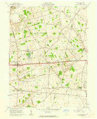
1961 Map of Vienna
USGS Topo · Published 1962About this map
Vienna and the surrounding agricultural landscape of Harmony and Pleasant townships appear here during a period of mid-century infrastructure growth. The National Road serves as a central east-west corridor, passing through Brighton and connecting the region's farming communities. To the southeast, the extensive grounds of the London Correctional Institution and the State Fish Hatchery mark significant state land use near the New York Central Railroad tracks.
Find a feature on this map
69 named features on this map. Tap any name to fly to it.
Don’t see what you’re looking for? This feature index may not catch every label — zoom into the map to look around manually.
Map Details
Editions of this 1961 Vienna Map
Other maps of this area

1907 · London
USGS Topo · 1:62,500

1907 · South Charleston
USGS Topo · 1:62,500

1914 · Mechanicsburg
USGS Topo · 1:62,500

1916 · Mechanicsburg
USGS Topo · 1:62,500

1916 · Milford Center
USGS Topo · 1:62,500

1944 · Mechanicsburg
USGS Topo · 1:62,500

1944 · Milford Center
USGS Topo · 1:62,500

1947 · Columbus
USGS Topo · 1:250,000

1950 · Marion
USGS Topo · 1:250,000

1961 · Columbus
USGS Topo · 1:250,000