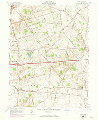
1961 Map of Vienna
USGS Topo · Published 1968About this map
Agricultural lands and rural crossroads define this 1961 survey of the Virginia Military District Between the Miamis, where the village of Vienna (South Vienna PO) sits along the historic National Road. The landscape is a network of small family settlements and burial grounds, including McConkey Cem and Bodkin Cem, reflecting generations of local residency. Further south, the Penn Central railroad cuts through Plattsburg, a key transit point for the region's produce and livestock.
Find a feature on this map
46 named features on this map. Tap any name to fly to it.
Don’t see what you’re looking for? This feature index may not catch every label — zoom into the map to look around manually.
Map Details
Editions of this 1961 Vienna Map
Other maps of this area

1907 · London
USGS Topo · 1:62,500

1907 · South Charleston
USGS Topo · 1:62,500

1914 · Mechanicsburg
USGS Topo · 1:62,500

1916 · Mechanicsburg
USGS Topo · 1:62,500

1916 · Milford Center
USGS Topo · 1:62,500

1944 · Mechanicsburg
USGS Topo · 1:62,500

1944 · Milford Center
USGS Topo · 1:62,500

1947 · Columbus
USGS Topo · 1:250,000

1950 · Marion
USGS Topo · 1:250,000

1961 · Columbus
USGS Topo · 1:250,000