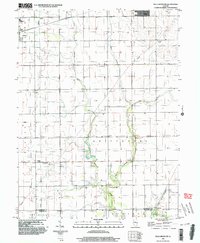
1998 Map of Villa Grove NW
USGS Topo · Published 2003About this map
The Embarras River meanders southward through this landscape, marking the transition between the townships of Philo, Crittenden, and Pesotum. The terrain is defined by its drainage network, including Black Slough, the East Branch, and the distinctively named Jordan Slu in the southeastern corner. This area of Champaign County preserves the social infrastructure of rural Illinois at the turn of the 21st century, from the Townhall in Crittenden to the Unity High Sch near Tolono. Local history and genealogy interest is anchored by features such as Jessee Cem and St Mary Sch, reflecting the established community patterns and religious foundations of the region. The map also captures modern utility and communication landmarks like the Pumping Station and Comm Tower, juxtaposed against the enduring section lines of the Public Land Survey System.
Find a feature on this map
19 named features on this map. Tap any name to fly to it.
Don’t see what you’re looking for? This feature index may not catch every label — zoom into the map to look around manually.
Map Details
Editions of this 1998 Villa Grove NW Map
This is the sole edition of this map. No revisions or reprints were ever made.
Other maps of this area

1906 · Urbana
USGS Topo · 1:62,500

1907 · Mahomet
USGS Topo · 1:62,500

1950 · Tuscola
USGS Topo · 1:62,500

1956 · Villa Grove
USGS Topo · 1:62,500

1957 · Urbana
USGS Topo · 1:62,500

1957 · Urbana
USGS Topo · 1:24,000

1957 · Mahomet
USGS Topo · 1:62,500

1957 · Bondville
USGS Topo · 1:24,000

1958 · Peoria
USGS Topo · 1:250,000

1958 · Decatur
USGS Topo · 1:250,000