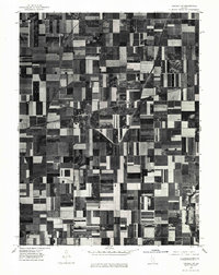
1975 Map of Tuscola NW
USGS Topo · Published 1977About this map
Ivesdale serves as the primary community anchor in this 1970s orthophotoquad, showing the intricate grid of agricultural land use in central Illinois. This aerial-based perspective captures the precise boundaries of farm plots and the distinct transport corridors that define the local economy. In the lower right, the Kaskaskia River cuts through the geometric landscape, providing a natural contrast to the surveyed field lines. This document is a valuable record for researchers interested in mid-1970s land management and the layout of rural settlements just before the transition to modern precision farming. The rectified photoimagery offers a clear look at the physical structures and farmsteads scattered throughout the quadrangle, illustrating the spatial relationship between the village and its surrounding acreage.
Find a feature on this map
2 named features on this map. Tap any name to fly to it.
Don’t see what you’re looking for? This feature index may not catch every label — zoom into the map to look around manually.
Map Details
Editions of this 1975 Tuscola NW Map
This is the sole edition of this map. No revisions or reprints were ever made.
Other maps of this area

1907 · Mahomet
USGS Topo · 1:62,500

1937 · Monticello
USGS Topo · 1:48,000

1943 · Monticello
USGS Topo · 1:62,500

1950 · Tuscola
USGS Topo · 1:62,500

1955 · Bement
USGS Topo · 1:62,500

1957 · Mahomet
USGS Topo · 1:62,500

1957 · Bondville
USGS Topo · 1:24,000

1958 · Peoria
USGS Topo · 1:250,000

1958 · Decatur
USGS Topo · 1:250,000

1961 · Peoria
USGS Topo · 1:250,000