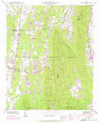
1946 Map of Villanow
USGS Topo · Published 1975About this map
Chattahoochee National Forest dominates this mid-century landscape in northwest Georgia, where the ridges of Rocky Face Mountain and Johns Mountain rise above the agricultural valleys of Armuchee Valley and Hurricane Valley. The 1946 field survey, with purple-ink revisions from the late 1960s, documents a community-centered landscape anchored by the settlement of Villanow. Local history is preserved through numerous family-named landmarks and rural institutions, including Lindsey Memorial Ch and Fairview Sch.
Find a feature on this map
48 named features on this map. Tap any name to fly to it.
Don’t see what you’re looking for? This feature index may not catch every label — zoom into the map to look around manually.
Map Details
Editions of this 1946 Villanow Map
3 editions found
Other maps of this area

1886 · Dalton
USGS Topo · 1:125,000

1886 · Ringgold
USGS Topo · 1:125,000

1892 · Ringgold
USGS Topo · 1:125,000

1892 · Dalton
USGS Topo · 1:125,000

1897 · Dalton
USGS Topo · 1:125,000

1935 · Catlett
USGS Topo · 1:24,000

1935 · Villanow
USGS Topo · 1:24,000

1935 · Nickajack Gap
USGS Topo · 1:24,000

1935 · Tunnel Hill
USGS Topo · 1:24,000

1938 · Chatsworth
USGS Topo · 1:48,000