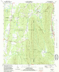
1983 Map of Villanow
USGS Topo · Published 1983About this map
The community of Villanow sits at a strategic valley crossroads in Northwest Georgia, where the Lookout Mountain Scenic Hwy transitions through the gaps of the Ridge and Valley province. This 1983 survey reveals a landscape defined by sharp mountain ridges, including Johns Mountain and Rocky Face Mountain, which separate narrow, fertile valleys like that of East Armuchee Creek. The land use is a mix of public conservation within the Chattahoochee National Forest and rural settlements clustered around family names and local congregations. Numerous small cemeteries, such as Cavender Cem and White Cem, are scattered throughout the valleys, providing a genealogical record of the region's long-established residents. The presence of the Tennessee Alabama and Georgia rail corridor and historic gaps like Snake Creek Gap highlights the region's importance as a passage through the Appalachian foothills.
Find a feature on this map
58 named features on this map. Tap any name to fly to it.
Don’t see what you’re looking for? This feature index may not catch every label — zoom into the map to look around manually.
Map Details
Editions of this 1983 Villanow Map
This is the sole edition of this map. No revisions or reprints were ever made.
Other maps of this area

1886 · Dalton
USGS Topo · 1:125,000

1886 · Ringgold
USGS Topo · 1:125,000

1892 · Ringgold
USGS Topo · 1:125,000

1892 · Dalton
USGS Topo · 1:125,000

1897 · Dalton
USGS Topo · 1:125,000

1935 · Catlett
USGS Topo · 1:24,000

1935 · Villanow
USGS Topo · 1:24,000

1935 · Nickajack Gap
USGS Topo · 1:24,000

1935 · Tunnel Hill
USGS Topo · 1:24,000

1938 · Chatsworth
USGS Topo · 1:48,000